Utility investigations by professionals, using professional standards
Professional investigation and analysis of below and above-ground utilities, using appropriate engineering practices, provides the reliable information project owners and designers need to manage the impact of existing utilities on projects to avoid costly problems during construction. Our professionals provide the technical insight and quality information you won’t get anywhere else. There is a lot to know about Subsurface Utility Engineering (SUE) and choosing the right consultant to work with is important.
T2ue uses the 2022 updated version of ASCE 38 as a valuable resource for identifying utilities that may be affected by project development and construction. T2ue also uses ASCE's SUE for Municipalities as a template to develop ASCE 38 compatible scopes of work. T2ue can conduce other utility-related services. Call us to discuss your project needs.
Why use Subsurface Utility Engineering?
Reliable information to identify & reduce utility risks
We have the right mix of professional engineers, surveyors, geophysicists, field technicians and technologists, CAD and GIS personnel to efficiently and effectively complete your project.
Services include, but are not limited to; records research, designating, locating (vacuum excavation), surveying, project management, professional analysis and quality assurance. T2ue's extensive technology can be leveraged for a wide variety of other project purposes.

Our professionals are fully versed in applying ASCE 38 Standards for project design, as T2 Utility Engineers personnel have been part of the ASCE Standards committee since its creation in 1996 and these are part of our best practices. We’re proud to lead the profession by participating in and leading standards and industry committees, authoring manuals of practice, supporting research, and training our staff.
We maximize your investment with professional consulting
As the SUE consultant, we recommend the most appropriate project scope based on the complexity of the site and each client’s project-specific tolerance for risk. This is another area where our experience comes in. Less experienced SUE providers and clients may either under or over-estimate what is required, leading to expensive change orders and inaccurate or incomplete information. Engaging T2 Utility Engineers' professional team early in the design process helps ensure the appropriate investigation is scoped for the project, maximizing your investment by reducing the project utility risk. This results in cost savings, reduced schedule delays, and improved project safety.
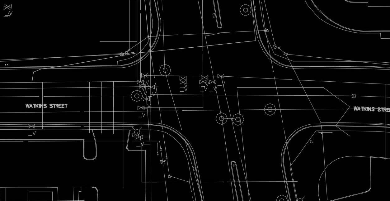
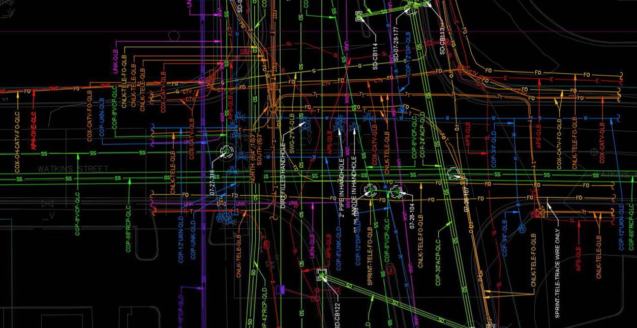
Left shows original QLD records: Right shows additional utilities found by T2ue investigation achieving QLB. Our investigation found 82% more utilities, 2 miles of unknown utilities, and eliminated the need for 2800 planned test holes saving the client millions of dollars.
SUE Quality Levels
T2ue follows ASCE 38 Standards in order to find and document the most likely location of utilities within a scope of work. The results are shown using the concept of a utility Quality Level for each utility segment, which reflects the certainty of the investigative results. The American Society of Civil Engineers (ASCE) developed Standard Guideline for Investigating and Documenting Existing Utilities, ASCE 38-22, which clarifies the Quality Levels as:
Quality Level D (QLD)
This achieved Quality Level has the lowest certainty. The location and other attributes are solely from interpretation and analysis of records or One-Call
Quality Level C (QLC)
This achieved Quality Level has more certainty than QLD. Any records / One-Call information is augmented by an accurate topo survey of visible utility features.
Quality Level B (QLB)
This achieved Quality Level is most often the goal of a SUE investigation. Utility location data is discovered and documented through appropriate surface geophysical techniques with results surveyed to appropriate project controls.
Quality Level A (QLA)
This achieved Quality Level conveys the highest assurance of certainty. A utility is exposed, accurately surveyed and identified, when possible, as to its function and ownership. QLA is typically documented at specific points of interest based on site conditions and project requirements.
Technology and Service Innovation
At T2ue, we are committed to providing exceptional value. We have developed our utility investigation processes with cost-effective and industry-leading technology and professional insight that reduces the risks from unknown utilities. In addition to providing a full complement of traditional SUE services, we offer our clients new technologies, innovative approaches and techniques to resolve specific challenges or further project goals. That’s our goal- to provide you with professional guidance on new practices to solve your challenges.
3D Modeling
Project design is increasingly moving to 3D models. While 3D modeling has typically been used for large linear projects, like transportation, many projects with complex underground utility infrastructure can benefit from adding this three dimensional modeling to a SUE investigation. The resulting information provides the additional detail and visuals that help enable the project design team to better understand the horizontal and vertical conflicts with a proposed design, and address them early in the process.
Building a 3D model starts with obtaining Quality Level B data in a 2D SUE drawing, and then adds depth information based on physical measurements, assumed depths and record information. As we introduce this information into the model, it’s important to understand and work closely with our clients to ensure the level of detail that is achieved matches the requirements of the project scope. Once the 3D SUE model is complete, it can be seamlessly referenced directly into any roadway, bridge, or other design file.
Our experienced professionals bring a diverse perspective and approach to any project. These diverse perspectives coupled with our expertise in accurately mapping existing utility infrastructure gives us a unique understanding of what’s required to create 3D SUE models that help mitigate utility risk. Contact us to talk about the benefits of this exciting technology.


Advanced Geophysics
Geophysical techniques complement traditional methods and allow the targeted use of non-invasive technologies to image subsurface conditions through measuring, analyzing and interpreting physical properties. Our skilled teams offer advanced geophysics to collect reliable data. We apply our experience and knowledge to the data to provide quality deliverables that reduce the uncertainty of underground utilities, other anomalies and unknowns. Our in-house equipment includes:
- Multi-Channel GPR (MCGPR) Radar Tomography
- Time Domain metal detector (EM61)
- Ground conductivity
- Indoor/Concrete scanning GPR
CCTV Investigations
T2 Utility Engineers team of engineers and technicians understand the working aspects of sewer and storm drain infrastructure and provide full CCTV services following National Association of Sewer Service Companies (NASSCO) – PACP, MACP, and LACP standards. We offer state-of-the-art CCTV equipment, zoom cameras and other tools necessary to provide inspection, condition assessment, horizontal positioning, and asset management services for sewer systems.
On the cutting edge of sewer inspection technology, our CCTV equipment enables us to side launch up a lateral from the mainline sewer, both with or against the mainline flow, to inspect and horizontally position the laterals. These investigations reduce the unknown risks typically associated with sewer laterals.
CCTV services include:
- Mainline CCTV inspection, horizontal positioning & condition assessment
- Lateral CCTV inspection, horizontal positioning & condition assessment
- Zoom camera inspections
- Cross bore prevention and inspection programs
- Maintenance hole inspections
- Smoke testing
- Dye testing
- Inflow and Infiltration (I&I) studies
- Cleaning and flushing
- Sewer reaming


Field Data Collection platform
T2ue has implemented a Field Data Collection platform to streamline data collection as well as improve quality control. Our Field Data Collection app utilizes mobile devices, which enables our field staff to automatically upload SUE data and site photos in real-time, providing our office team with immediate access to spatially georeferenced data. This web-based tool allows T2ue to share information with clients and owners in real time, for increased collaboration.
We have the ability to
- Generate Health & Safety reporting
- Record Pre-Trip Vehicle Inspection
- Record date, time, weather, lat/long, etc.
- Collect field data (designating & test holes)
- GPS track the work location
- Add photographs and generate a photo report
- Perform QC of the field data (manager, inspector, supervisor)
- Create reports
- Share information in real-time with clients/owners
- Generate project deliverables
Chamber Scanning
T2ue offers chamber scanning to collect highly accurate and precise 3D data that can be integrated directly into project design files. We utilize a variety of technologies to provide additional detail for both above- and below-grade utility-related structures and features, particularly in congested corridors that benefit from this additional level of detail. These advanced scanning techniques are well-suited for confined space areas and can be incorporated in a variety of site investigations, including bridge piers, tunnels, ducts, vaults, manholes, and more.


Multi-Channel GPR (MCGPR) Radar Tomography
Multi-Channel Ground Penetrating Radar (MCGPR) technologies are among the most innovative available for subsurface investigations. Due to our industry leadership position and partnerships, T2ue participated in much of the early development of these new systems and have integrated this equipment into our services. MCGPR works similarly to traditional GPR, but provides much greater data density through a larger array. This technology provides a more accurate depiction, which allows us to provide a more comprehensive and thorough investigation, beyond standard GPR 3D positioning of utilities. Using MCGPR as one of our investigation techniques, we’ve been successful in documenting voids, old construction rubble, buried vaults, buried and long-forgotten railroad tracks, pipe trestles, and other anomalies, in addition to utilities that would impact project construction.
MCGPR data is collected with minimal traffic disruption compared to traditional methods because the unit is towed behind a vehicle. This also improves project safety. Once the data is collected, data interpretation is the key to using it effectively. Our team has years of experience interpreting different types and levels of data and that makes a big difference in the quality of the final deliverables. Because of the expense and complexity, not many firms offer this service. You can rely on T2 Utility Engineers' experience to identify when MCGPR would be appropriate for a project.
For extensive detail about MCGPR, see our article What is MCGPR.
Where We Work - Experience Makes the Difference
T2 Utility Engineers has the experience to handle projects of any size and complexity in the US and Canada. Since 1993, we have supported transportation, industrial, water/wastewater, energy, campus, municipal capital improvement, and asset management projects. We are proud to have been selected by clients from municipalities and engineering consultants to the largest federal agencies. Whether your project is traditional delivery, design-build, P3, Progressive Design-Build, or CMAR, our knowledge and experience enhance our ability to recommend the appropriate scope and schedule of the investigative effort.