In this article, we’ll review what MCGPR is, how MCGPR works, how MCGPR is different from traditional GPR, and when MCGPR is recommended for Subsurface Utility Engineering (SUE) investigations.
The evolution of Ground Penetrating Radar (GPR) has led to Multi-Channel Ground Penetrating Radar (MCGPR), a non-destructive advanced geophysical technology for investigating and mapping underground information with increased data density, accuracy, and efficiency. As a result, MCGPR is a highly effective technology as part of a SUE investigation for specific projects.
What is Multi-Channel Ground Penetrating Radar (MCGPR)?
The basic principles of Multi-Channel GPR are the same as traditional GPR, transmitting frequencies in the radio spectrum and interpreting the reflections created.
Traditional GPR is typically single or double-channel real-time data collection and creates a 2-dimensional image, that is generally best used where real-time interpretation of data is needed such as individual utility or structure verification, or smaller target areas. Creating a 3D image with traditional GPR is quite time-consuming, due to the amount of field collection and the data processing required. This is where MCGPR comes in.
MCGPR helps solve a limitation from traditional GPR by having multiple channels collecting data in both directions as well as multiple frequencies in a single 3D GPR array, allowing an extremely dense data collection. This dense data set can create a more comprehensive 3-dimensional image of the subsurface in a single scan.
When to use MCGPR? Faster, More Comprehensive Data
MCGPR technology uses multiple channels to collect high resolution, closely spaced data in both directions as well as utilizing multiple frequencies that combine into a single GPR array. The extremely dense data that is collected can be processed into a comprehensive 3-dimensional image. Capturing this high-density data, MCGPR can provide more accurate detail and the ability to accurately identify more underground anomalies over large areas and/or in areas with high levels of congestion.
Processing and interpreting the data requires experience, rather like a radiologist identifying what to make of imagery in an MRI/CAT scan. T2ue has been using MCGPR technology to provide advanced insight for Subsurface Utility Engineering investigations for more than 10 years. If a project requires a high level of detail, MCGPR is a great tool to efficiently capture the data necessary to augment utility drawings for the Subsurface Utility Engineering (SUE) investigation.

Typical GPR is analogous to an xray.
MCGPR is similar to an MRI.
MCGPR Minimizes Disruption and Improves Safety
The MCGPR towed arrays distinguish themselves by collecting and analyzing data across a much larger area with a faster field collection time, as well as increased accuracy and resolution. In addition, the data can be collected very safely and with minimal traffic disruption. MCGPR towed arrays can capture data while driving at road speeds, so road closure or field crews in the roadway are not necessary. This is ideal for projects that cover large areas in densely populated corridors or have a lot of roadway congestion.
The inclusion and ease of geospatial positioning allow for collection in a reduced field time to help with the safety of staff and lower public disruptions. It allows for the relatively quick processing and geo-referencing of large areas of data.
As an example, T2ue used MCGPR for a utility investigation on the Las Vegas strip, an area of highly dense underground utilities that required night work to minimize impacts to traffic, as well as supporting public safety.


MCGPR can collect a lot of data in a short time frame, even in live traffic.
What Does MCGPR Data Show?
In the right conditions and with the right post-processing, MCGPR can generate high-resolution images and ultimately 3-dimensional data of the subsurface. Utilizing array systems allows mapping of the underground including utilities, trenches, pits, voids, archaeology, structures, and unknowns.

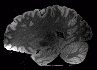
Railways and old concrete footings can be seen in the image above, in what appeared to be a level parking lot.
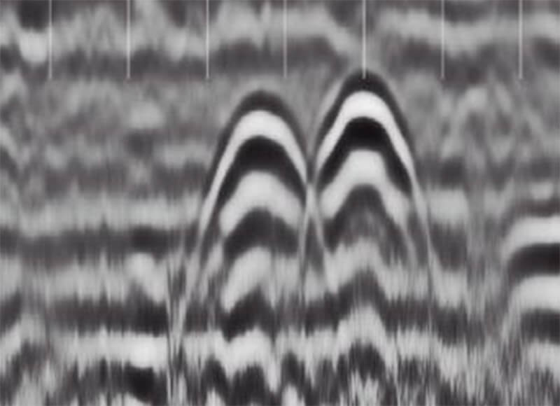
After data is collected it is processed to create a map/tomography of the scanned area, the position and relative depth of the subsurface features are indicated.
Integrating survey information with this high-density MCGPR data more efficiently presents and greatly increases the data available for interpretation and leads to improved visualization. Displaying data in different ways included within a CAD file, Google Earth, and MicroStation improve the transfer of data for easier decision making.

3D image of an MCGPR result demonstrating depths and alignment.
When MCGPR data is connected to survey data and georeferenced against a SUE investigation data- set, it functions as a good cross-reference since it can show whether utilities are in conflict and may need to be realigned against existing data. In addition, it can help identify non-conductive structures such as PVC piping, unknown or abandoned utilities, or non-utility structures.
- Creates a “double-check” of investigation
- May identify unknown Utilities and structures not caught by the base investigation reducing risk
- Independent evaluation process
- May show shifts in utilities not able to be identified in base investigation
- Helps with elevation and collaborating test hole information

Tomography on a SUE deliverable.
Evaluating When to Use MCGPR Technology – Professional Expertise Matters
The use of MCGPR systems is a very effective way to gather a large amount of information over a large area more quickly than traditional GPR. It allows for the collection of high-density data over varying coverage areas by using the most appropriate type of equipment, such as wide towed arrays at road speed or smaller push/towed systems for tighter areas.
MCGPR is a great technology to consider for many projects but isn’t a complete solution on its own. It needs to be used in the right situations and in conjunction with the right equipment, processing, and interpretation to be reliable and efficient. Factors such as soil type, the types of subsurface features to be located, the amount of information, and the certainty the project requires all go into the decision to use MCGPR. Our T2ue professionals have the experience to provide insight and recommendations on whether MCGPR may be a good choice for your project.