T2 Utility Engineers (T2ue) delivers advanced No-Entry Confined Space Scanning solutions that improve safety, accuracy, efficiency, and data quality in utility investigations and condition assessments. Using technologies like photogrammetry and LiDAR, T2ue collects detailed, consistent, and actionable data that is compliant with ASCE 38-22 requirements without the limitations and risks associated with traditional methods.
In this article:
- What is No-Entry Confined Space Scanning?
- Deliverables: What We Can Provide
- How Does This Improve Deliverables?
- Technologies Employed
- Limitations of Traditional Methods
- Advantages of No-Entry Confined Space Scanning
- What Types of Projects Benefit From No-Entry Confined Space Scanning?
- Project Examples
What Is No-Entry Confined Space Scanning?
No-Entry Confined Space Scanning uses remote scanning technologies to digitize and automate portions of the confined space data collection process. Compared to traditional methods, such as physical confined space entry or surface-based measurements, this approach is faster, safer, and can meet the new quality level requirements of ASCE 38-22. This allows for the collection of data to achieve a higher Quality Level than may have been attainable due to time and budget constraints associated with traditional data collection methods.
With advanced photogrammetry and LiDAR technology, our trained and skilled operators can collect comprehensive and reliable spatial information in minutes. The data is then processed off-site by a qualified professional for use in utility investigations and engineering, condition assessment, documentation, and more. This process unlocks deeper utility insights such as documenting structure details in accordance with ASCE 38-22 and delivering added quality assurance checks that strengthen project confidence and outcomes. The result: higher-quality deliverables, improved certainty, and better insights.
Data Collected Includes:
- Invert elevations
- Size, shape, and material of structures and components
- Chamber geometry
- Utility attributes: size, quantity, orientation, configuration, and type
- 360° immersive video
- Point clouds for CAD and 3D modeling
- Condition assessments (NASSCO-certified)
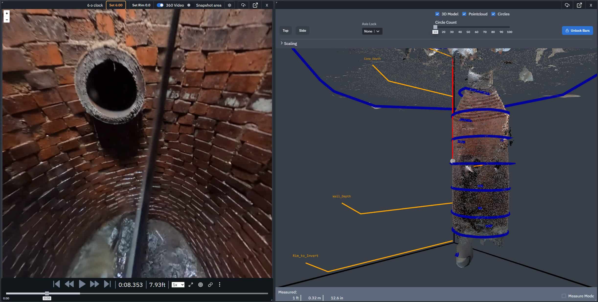
Confirm invert elevation to engineering standards
Chamber Geometry ringsMaps the spatial characteristics of a chamber of space to high accuracy
Pipe DiameterPipes and other features can be measured to a quantifiable certainty right from the 3d model and allows for measurements no possible from surface-based observation.
Sewer LineData captures info to inspect utility type, configuration, and orientation
360-degree immersive videoCamera captures the immersive footage of the entire chamber in 360 degrees.
Point CloudPoint cloud generated by photogrammetry.
Camera Position MarkerRed line marks the position of the video camera in the 3d model in real time.
Example scanning output from a photogrammetry chamber scan. Hover over the circles to view details.
Deliverables: What We Can Provide
Depending on project goals and technology used, deliverables may include:
- 3D model data and renderings
- 360° immersive VR video
- Utility chamber attribute reports with photos
- Butterfly diagrams showing utility configurations
- High-resolution imagery of findings
These outputs can be delivered as standalone files or integrated into broader utility investigations, as shown in the examples below. For photogrammetry-based investigations the results can be delivered and viewed over the web, without the need for specialized software.
Below is an interactive VR video, click and drag within the frame to look around.
How Does This Improve Deliverables?
No-Entry Confined Space Scanning enhances deliverables by enabling direct observation of subsurface features without introducing additional complexity to utility investigations. This approach supports compliance with the prescriptive requirements of ASCE 38-22, allowing teams to achieve higher Quality Levels and produce more reliable, comprehensive data. The result is greater certainty for project decisions and reduced utility-related risk.

Achievement of Higher Quality Levels
ASCE 38-22 introduced stricter criteria for Quality Level designations. For example, achieving QLC now requires chamber dimensions and direct observation of pipe entry points-data that often wasn't collected due to the time, cost, and safety constraints associated with traditional methods. Without this information, utility segments were typically mapped using records and classified as QLD, the lowest certainty level. No-Entry Confined Space Scanning overcomes these limitations, enabling QLC compliance and improving confidence in utility mapping.

Better Documentation
Direct observation inside utility chambers allows for detailed inventory and configuration diagrams that were previously impractical to collect. This includes butterfly diagrams, cross-referencing utilities outside the chamber, and noting conditions such as capped pipes for better status insight. By capturing this data efficiently, projects gain richer documentation and a more accurate understanding of existing infrastructure-without the delays and hazards of traditional entry methods.
Technologies Employed
Photogrammetry extracts reliable measurements and 3D models from photographs. A compact data collector that is lowered into the chamber, capturing images and 360° immersive video quickly without requiring personnel to physically enter the space. This data is then processed into 3D models, point clouds, and inventory reports.
Key Benefits:
- Access immersive 360° video and corresponding models of recessed manholes and vault features
- Allows verification of size, quantity, and condition with high-quality visual checks
- Improves safety by minimizing or eliminating confined space entry
- Remote data collection allows faster field work
- Strengthens utility documentation and mapping
- Meets requirements for a compliant ASCE 38 utility investigation

LiDAR (Light Detection and Ranging) uses laser pulses to create dense point clouds with millimeter-level accuracy. Like photogrammetry, LiDAR units are deployed remotely from the surface, ensuring safety and efficiency.
Key Benefits:
- Similar benefits to safety, speed, documentation, and ASCE 38-22 compliance as photogrammetry-based scanners
- Access to 3D model of recessed manholes and vault features
- Suitable for larger vaults where the entire space can't be sufficiently illuminated for photogrammetry-based scanners
- Increased accuracy when compared to photogrammetry can benefit projects with tight tolerances
- Can scan in dark or light environments and gathers data on all surfaces and features within the line of sight, such as pipes, openings, or other features extending outward from the chamber or vault.

Limitations of Traditional Methods
Before the introduction of advanced subsurface scanning tools, data collection relied primarily on two approaches: surface-based measurement or physical confined space entry. While each method has its place, both introduce challenges and drawbacks that modern No-Entry techniques can effectively overcome.

Physical Confined Space Entry
This approach requires personnel to physically enter the confined space to collect measurements, capture photos, and assess conditions. It carries unavoidable safety hazards, and mitigating these risks demands specialized equipment, extensive training, additional time, and proper staffing.
Limitations:
- Significant safety risks
- High staffing and training requirements
- Longer execution time compared to modern methods
- Increased susceptibility to human error
- No video record for future reference

Surface-Based Measurement
This method uses tools lowered into the subsurface space, such as a ruler attached to a pole, to take measurements from the surface. While safer than physical entry, observations are limited by chamber depth and the restricted vantage point at the access opening.
Limitations:
- Limited visibility and access from the surface
- Vulnerable to human error and spatial constraints
- Slower than subsurface scanning tools
- Requires field training for accurate measurements
- No video record for documentation or later review
Advantages of No-Entry Confined Space Scanning
-
ASCE 38-22 Compliant
Can meet the more stringent Quality Level requirements of ASCE 38-22 without physical confined space entry.
-
Speed
Eliminates the need for physical entry, reducing traffic control, permitting, and setup time. More data can be collected in less time.
-
Accuracy
Provides consistent, quantifiable results with reduced human error compared to manual methods.
-
Safety
Removes the need for personnel to enter confined spaces, minimizing exposure to hazardous conditions.
-
Improved Documentation
Digital deliverables allow for virtual review at any time, offering a more comprehensive record than traditional photos and notes.
What Types of Projects Benefit from No-Entry Confined Space Scanning?
In the United States we employ No-Entry Confined Space Scanning primarily for Utility Investigations, both Subsurface Utility Engineering and Modified Utility Investigations, and for other documentation or special projects.

Utility Investigations
Enables near-equivalent insights to physical entry, improving data quality and confidence in underground utility configurations.

Condition Assessment
Enables collection and assessment of data to use in condition assessment, including NASSCO certified inspections.

Special Projects
Ideal for unique subsurface environments such as tanks, voids, or other challenging spaces. Contact us to discuss your unique project requirements.
Project Examples

We are Ready to Mobilize, Contact Us Today!
Our team is ready to mobilize from any of our 38 offices across the United States and Canada. No matter what or where the project is, we're prepared to handle virtual confined space entry projects of any size. Our professionals do what it takes to get the job done. We've even travelled by train, helicopter, and boat to get to remote project locations requested by our clients. No matter what the job is we get it done right the first time, and pride ourselves on our reliability and straightforward professionalism.